GIS
Products
Topcon has entered into the GIS arena
with dead aim. The product line up
that the Topcon engineers have developed
is second to none. Again Topcon demonstrates
their ability to be innovative in developing “World
First” designs.
Here is a look into the beginning of our
GIS product portfolio.
Hardware
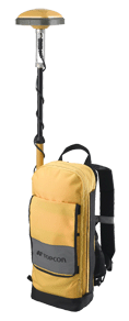
The GMS-2 is a small
hand held dual constellation satellite
tracking receiver that is packed with features
and performance. The GMS-2 was specifically
for the GIS market. It is small,
very light weight, extremely portable and
quite user friendly.
What sets the GMS-2 apart for the rest of
the field? It might be the fact that the
GMS-2 is the only GIS GPS hand held receiver
that incorporates an integrated camera & an
electronic compass! Or is it that the
GMS-2 is the only GIS receiver in the market
place that tracks GPS and GLONASS satellites?
Check it out. There is a whole lot more if
you look just a little deeper.

The GMS-110 with integrated
real time GIS correction services and multifunction
antenna will provide sub-meter accuracy
with real-time differential correction
from OmniSTAR and Navigational Beacons. The
system is also WAAS and EGNOS ready. The
added convenience of wireless Bluetooth
connection to your controller makes for
and extremely clean package without the
annoying cable.
You have the choice of two software packages
to run in your system. For
those GIS professionals who are plugged into ESRI ArcPad we have your solution
combining ArcPAD and the FC-100 controller. We also offer TopSURV-GIS which
is a simpler more straightforward solution.
Software
TopSURV-GIS is a module
of Topcon’s popular TopSURV field
survey software. TopSURV combines
basic survey functionality such as stakeout
and COGO with GIS feature and attribute
data collection. TopSURV-GIS would
be a perfect solution for an existing Topcon
customer who is familiar with Topcon software
and has GIS requirements. Data
can be exported to shape files of dxg files
directly from the handheld unit, or data
can be post-processed in Topcon Tools-GIS. TopSURV-GIS
offers the flexibility to work with GPS
units or Total Stations.

TopPAD data collection
software is based on an OEM version of
ESRI’s ArcPad software. This
would be the right choice for a customer
who is currently running ESRI software. ArcPad
users would eliminate the learning curve
when using TopPAD and the FC-100. The
field files generated by TopPAD will allow
the user to directly output in shape file
format. This speeds the process significantly. TopPAD
can store real-time corrected records and
also has the capability to log raw data
for post processing in Topcon Tools-GIS.

Topcon Tools-GIS allows
you to post-process GPS data back in the
office on your desktop computer. It
will also allow you to create feature and
attribute list, view and edit data, import
and export GIS and Cad data.
Please click
here to contact us |